Editor's Review
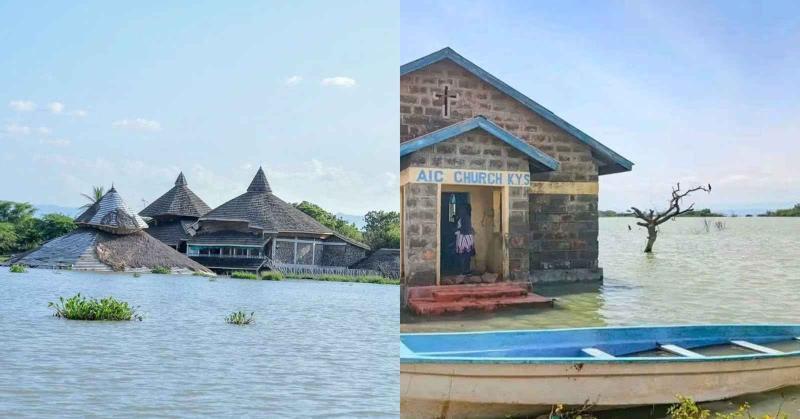
The government has unveiled plans to implement emergency flood control works in the Baringo-Bogoria Basin amid rising water levels.
The government has unveiled plans to implement emergency flood control works in the Baringo-Bogoria Basin amid rising water levels.
In a statement on Tuesday, August 18, Defence Principal Secretary Patrick Mariru said the proposed interventions are expected to support the development of irrigation downstream, with the government targeting the irrigation of at least 100,000 acres in Tiaty and surrounding areas.
"This afternoon, I co-chaired a technical review meeting at Maji House alongside the Principal Secretary for Irrigation, Ephantus Kimotho, to assess progress in the plans for the proposed Emergency Flood Control Works for the Baringo-Bogoria Basin. And the opportunity this challenge presents for irrigating not less than 100,000 acres downstream in Tiaty and beyond," he wrote.
According to Mariru, the meeting followed a joint government site visit to Lakes Baringo and Bogoria, where officials assessed the impact of the rising water levels, the extent of flooding and the risks facing communities, infrastructure and the environment.
He said the assessment also considered the possibility of the two lakes eventually merging as water levels continue to rise.
Read More
"The meeting follows our recent joint site visit to Lakes Baringo and Bogoria, where we assessed the effects of the rising water levels, the extent of flooding and the risks posed to communities, infrastructure and the environment, including the possibility of the two lakes eventually merging," he added.
Mariru said the government has received a report based on detailed field investigations, alongside a proposed workplan that will guide implementation of the planned interventions.
The report contains technical proposals developed from topographical and hydrological surveys, geotechnical assessments and conceptual engineering designs, which will inform measures to address the rising water levels and flooding.
"We received a comprehensive report based on detailed field investigations, together with a proposed workplan to guide the implementation of the planned interventions," he explained.

Mariru said the findings will also guide the development of sustainable flood-control measures while supporting a commercially viable irrigation programme downstream.
"The report presented technical proposals informed by topographical and hydrological surveys, geotechnical assessments and conceptual engineering designs. These findings will provide the basis for developing practical and sustainable measures to control the rising water levels and mitigate the impact of flooding in the basin. And at the same time, support a commercially viable irrigation program downstream," the statement concluded.
Meanwhile, Nairobi County has stepped up preparations for the expected El Niño rains after identifying 227 flood hotspots across 17 sub-counties.
According to a statement on Monday, August 17, the preparedness plan brings together several government agencies as the county begins implementing Ksh2.4 billion in drainage and flood-mitigation projects.
The coordination framework brings together the Kenya Red Cross, Kenya Urban Roads Authority (KURA), Kenya National Highways Authority (KeNHA), National Disaster Management Authority, Nairobi County Disaster Management Team, Environment Department, Nairobi Rivers Commission and other agencies.
Governor Johnson Sakaja said the involvement of multiple agencies would enable the county to prepare in advance, coordinate operations and respond more effectively to emergencies.
"This calls for us to prepare together, act early and protect lives and property," he said.
The county has set aside Ksh2 billion of the Ksh2.4 billion allocation for drainage and flood-control works covering 19 roads identified as vulnerable to flooding.
The projects are at an advanced stage, with tenders awarded and contractors expected to begin work once the remaining administrative processes are completed.
The drainage programme is intended to complement existing efforts under the Nairobi Regeneration Programme while addressing recurring flooding along roads and other essential infrastructure.
Sakaja said the investment is intended to provide a lasting solution to Nairobi’s persistent flooding problem by improving the city’s drainage system.
"The Ksh2 billion will support a comprehensive drainage overhaul that complements the ongoing Nairobi Regeneration Programme. Our goal is to permanently address the flooding challenges that have affected the city for many years," he added.
The 227 hotspots identified by the multi-agency teams will serve as key areas for preparedness measures, deployment of equipment and resources, as well as emergency interventions.
The assessment covers locations with blocked or undersized drainage systems, areas requiring desilting and waste removal, and river corridors and waterways vulnerable to obstruction.
The teams have also flagged roads and major transport routes prone to flooding, together with locations where heavy rains could restrict emergency access.
Communities considered vulnerable to the effects of flooding will receive particular attention, including areas that may require early warnings, evacuation, temporary shelter and relief assistance during emergencies.